
Voice of the Danube
Five years of collaboration have produced an impressive result: The Bulgarian Executive Agency for Exploitation and Monitoring of the Danube River has long endorsed the R&D activities of humanizing technologies lab Mozaika. The objective was building a customized information system to increase the Agency’s operational efficiency and analytical capabilities and to ensure optimal maintenance of the Danube’s fairway and continuous inspection of the hydrological status of the river. The result is the water resources management solution ISME-HYDRO®, created by Mozaika for exclusive use of the Agency.
Bozhidar Yankov, Secretary General of EAEMDR states:
"It was a difficult decision to embrace such a novel solution and to take the path towards adopting it on a daily basis, but seeing its impact on the work processes and the operational efficiency of our staff, we are certain that we have made a very good decision."
From August 2024, the Agency has had access to daily updated data from three monitoring stations – Lom, Svishtov, Silistra - and to 3, 5, and 7 day forecasts for water levels, generated by three different models based on cutting-edge EO4AI (earth observation for AI) methods. Mozaika applied a rigorous evaluation process on the forecasts, based on best hydrology standards, and added improvements to finally reach the exacting precision requirements set by the Agency, as shown on Table 1 below.
| Forecast days | ahead | ||
| 1-2 days | 3-5 days | ||
| Standard deviation (SD) | SD | 20> | 40> |
| Root mean squared error (RMSE) | RMSE | 20> | 40> |
| Efficiency coefficient | Efficiency | 0.9> | 0.8> |
| Nasch-Sutcliff model efficiency coefficient (NTD) | NTD | 0.95> | 0.85> |
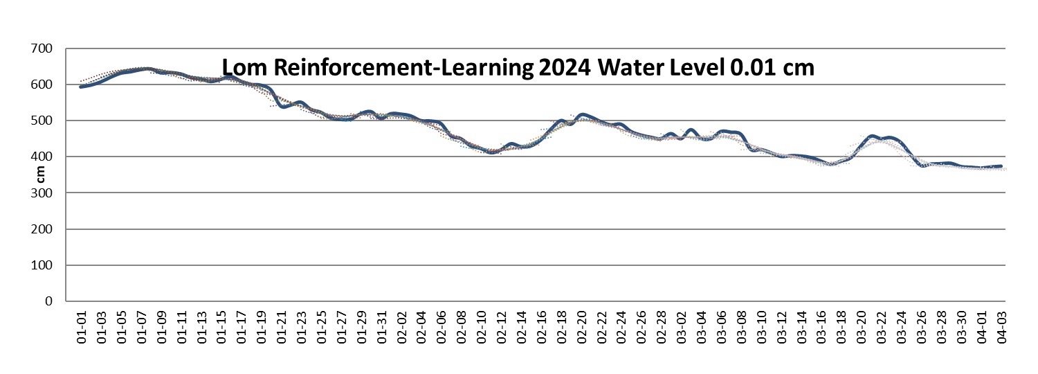
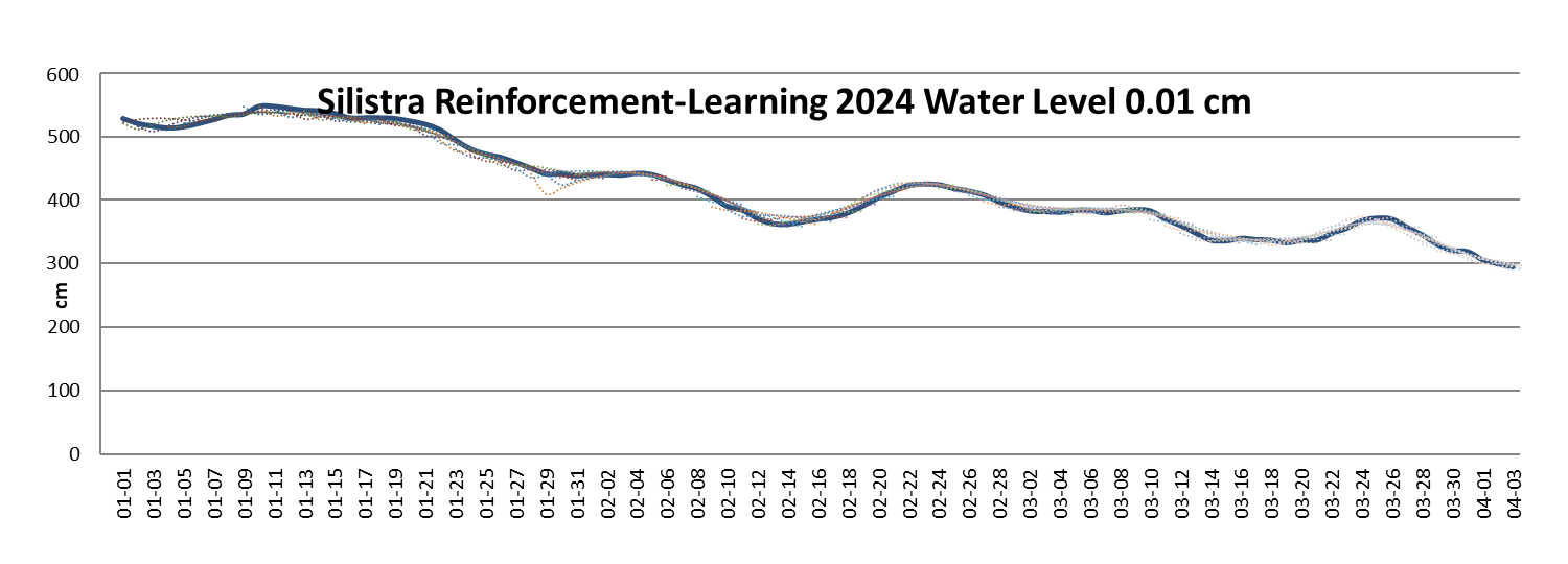
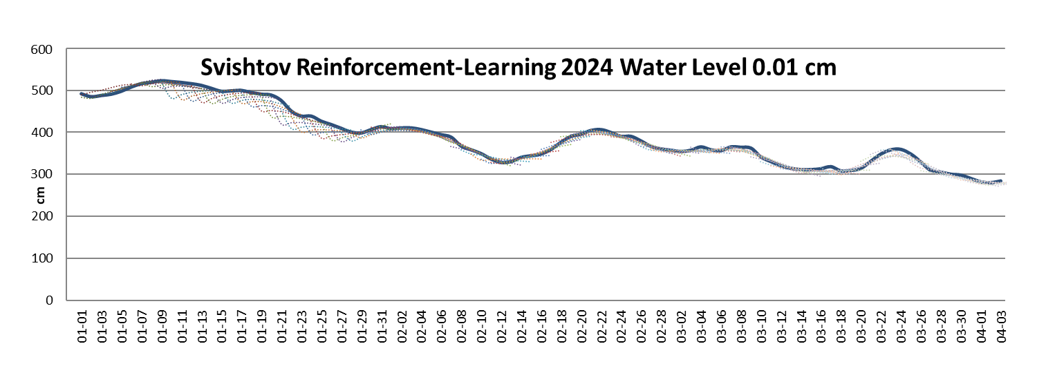
Beyond that, ISME-HYDRO® produced forecast result curves corresponding closely to the real measurement curves, as in Figure 1, where we apply professional hydrology methodology of representing the forecasts.

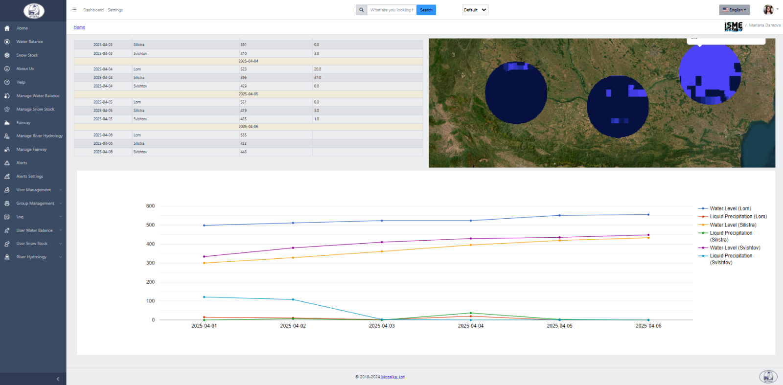
The interactive user interface of the ISME-HYDRO® application allows water resources managers to compare historic and forecast water level data, and historic meteorological data like precipitation, soil moisture, and vegetation index for the monitoring station locations.
Below, Figure 2 shows the results of the inquiry for water level and liquid precipitations for the three monitoring stations over the last 6 day period.
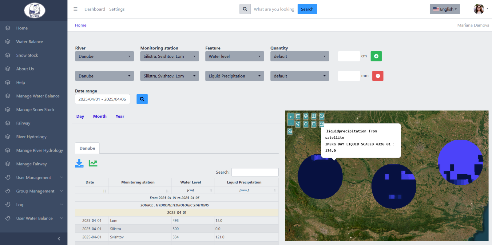
Additionally, Figure 3 displays the graph view of the water level and liquid precipitation values for the three stations over the 6 days period of the query.
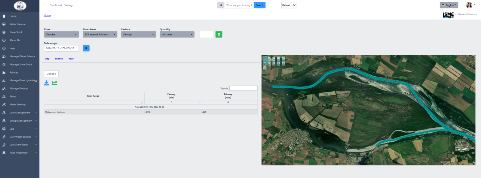
Apart from the hydrological monitoring, the application provides with a feature to monitor the upcoming changes in the fairway by displaying them on an interactive map in a form and shape similar to the daily CAD/CAM maps drawn by Agency analysts, as shown on Figure 4 below. These maps cover three designated critical areas on the lower stream of the Danube in the Bulgarian river segment. This feature is currently undergoing integration into the daily operations of the Agency.
Beyond a mere consumer role in interacting with ISME-HYDRO® data, Agency operators also act as data auditors, being authorized to upload and introduce data into the platform, and to modify, add and delete data as they deem necessary for their daily operations and analytical processes.
ISME-HYDRO® also issues alerts as advanced warnings for upcoming flood events or droughts, and notifications about the need to change fairway signaling.
Hristo Enchev, Chief Hydrologist of EAEMDR, highlights:
"Being able to provide with a range of tools to view, interrogate and operate with all data necessary for our daily responsibilities and to have a range of forecasts for critical for the maintenance of the Danube and the fairway features renders the execution of our duties easier and risk freer. In addition, it allows us to explore aspects of the states of the river that have not been possible before adopting ISME-HYDRO®."
After this successful deployment it is to be expected that the collaboration between EAEMDR and Mozaika will sustain and grow, and that it is time to start turning sight to other potential users on the upper streams of the Danube river.